WildSpace Image Analytics
Interpretative solutions in aerial imaging for wildlife survey, land use and machine learning
Services
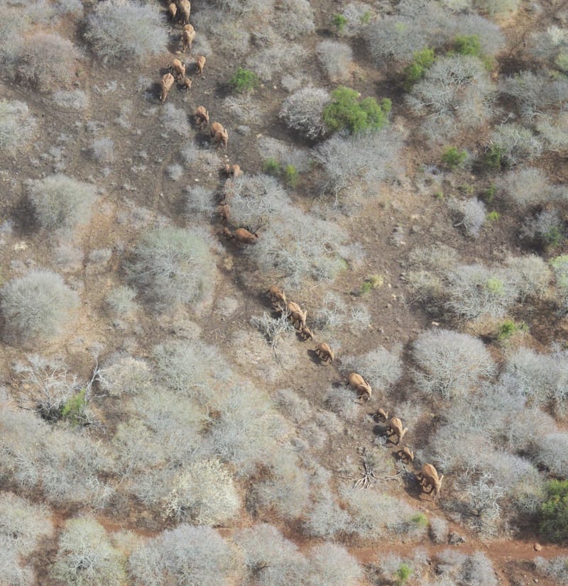
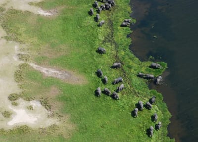
WILDLIFE AND LIVESTOCK POPULATIONS AND DISTRIBUTIONS
We specialize in gathering, indexing and interpreting large volumes of high-resolution aerial images (24 - 61 MegaPixel) for African wildlife, vegetation and human variables. We compile the geo-referenced information into comprehensive Excel meta-databases for population analysis (for example "Jolly II") and for deployment to clients for their own needs.
Learn More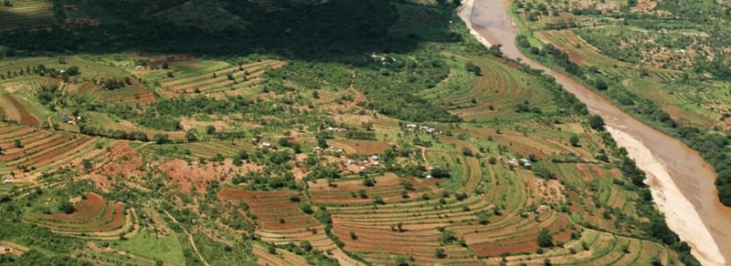
LAND USE ASSESSMENT AND AGRICULTURAL INVENTORY
We implement surveys using aerial-point-sampling (APS) methods to assess land use and crop systems, and implement agricultural inventories. Using high-resolution digital cameras, we map crop types at a resolution of 3 cm ground-sampling-distance (GSD) to derive land budgets at the scale of districts and regions.
Learn More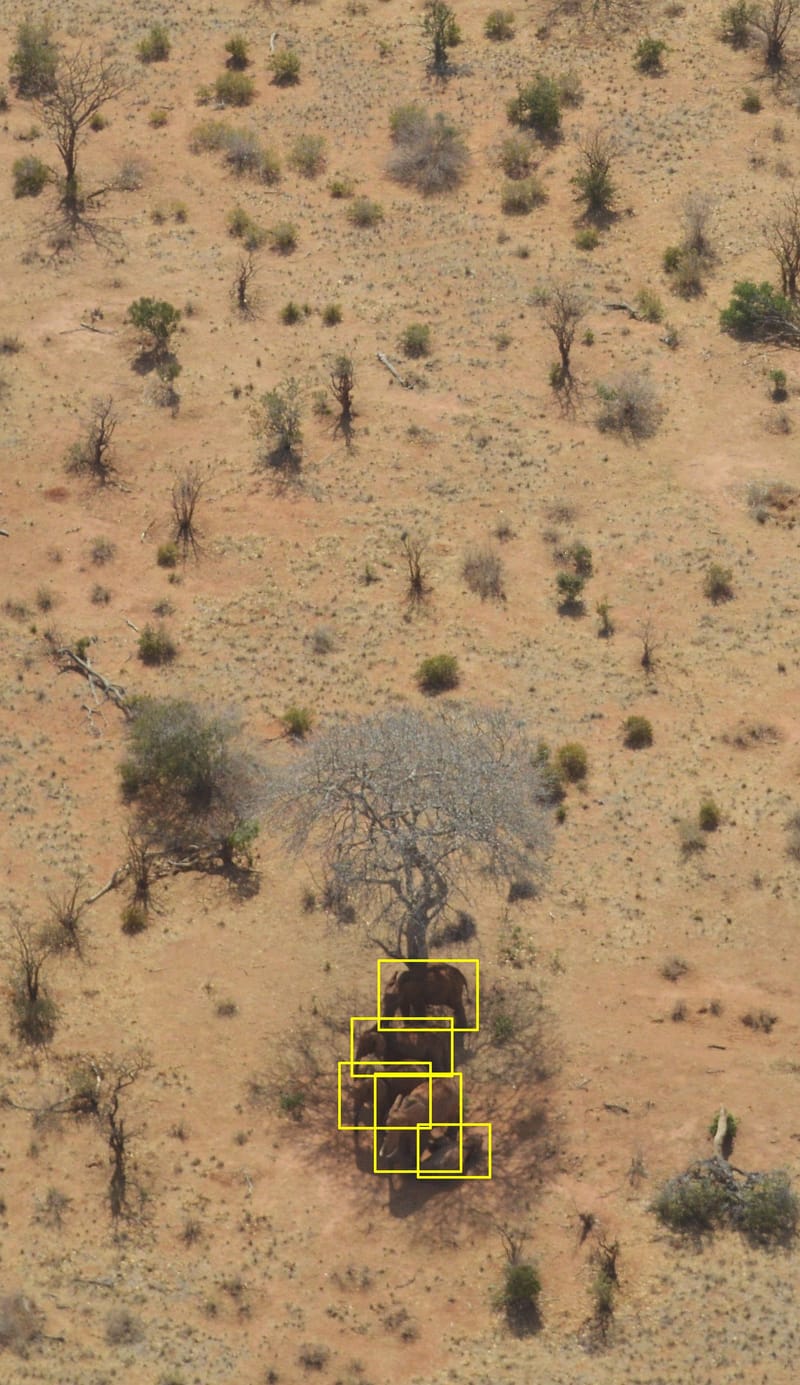
ANNOTATION FOR MACHINE LEARNING
Wildspace-Image-Analytics provides precise annotation for machine learning to help teams build high-quality training datasets for computer vision and AI models. We deliver consistent, scalable labels tailored to your taxonomy and use case to improve model accuracy and reduce time-to-deployment.
Learn MoreAbout
WildSpace Image Analytics (WIA) was launched in its early form in 2005 by Dr Richard Lamprey, a wildlife survey and remote sensing specialist based in East Africa, who has taken forward the use of small and medium format camera imaging for wildlife enumeration and land use assessment. Over the last 21 years we have been developing new techniques for survey using small-format digital cameras, and building up a dedicated Ugandan team of image interpreters who analyze the images. The WIA Team geo-reference, interpret and quantify a large range of variables including wildlife species, vegetation communities, crop types and human settlement. We compile the information into Excel meta-databases for analysis and for deployment to clients for their own needs.
As the first team in Africa dedicated to image-based wildlife estimation, we have a formidable experience in all aspects of aerial wildlife surveys using camera systems, especially in regard to integrating these techniques into the systematic reconnaissance flight (SRF) method and 'Jolly II' analysis for population estimation. We conduct the entire survey using digital camera systems, and interpret the acquired images in the laboratory. This involves visually scanning through thousands of images for the presence of animals, and detecting the 'True Positives' out of the many 'True Negatives'. Every animal detection is verified in the photographic record for future validation.
We offer a turn-key capability for wildlife census and crop monitoring based on the new 'camera-count' techniques we have developed, and which are now published in the peer-reviewed academic journals. Our published experiments reveal that 'traditional' aerial multi-species wildlife counts conducted over the last 60 years using human 'rear-seat-observers' (RSOs) may fail to detect many animals. For example, in Tsavo National Park in Kenya in 2017, the observers missed over 50% of the large mammals detected in the parallel imagery. Our camera-counts have therefore significantly increased wildlife population estimates, an example being Uganda where our surveys have boosted the national elephant population estimate by 70% in comparison with recent RSO-based estimates. This is surely an optimistic note in these troubled times for wildlife conservation.
Our counting techniques logically lead into image annotation for artificial intelligence/ machine learning, and we are pleased to offer bulk annotation services for automated object detection in the fields of wildlife census and crop systems. Our training annotations have formed a primary pillar for the WildMe Scout V2/V3 models (now further developed by Microsoft AI for Good), and for the Herd-Net model developed by the University of Liege/ Gembloux in Belgium.
To date, the team have acquired and interpreted over 1,000,000 images, and we are privileged to have conducted or analysis for the following clients:
2025 - 2026, KENYA and UGANDA; WildSpace is leading a high-sample-intensity aerial survey of Kidepo National Park, northern Karamoja Region of Uganda and the adjoining Turkana Province of north-western Kenya (survey area 42,000 sq.km). For the European Union's NaturAfrica Programme, with implementation through the Northern Rangeland Trust (NRT) of Kenya and the Uganda Conservation Foundation (UCF), and in collaboration with the Uganda Wildlife Authority (UWA), Kenya Wildlife and Training Institute (WRTI), Kenya Wildlife Service (KWS) and Uganda National Forestry Authority (NFA).
2025, UGANDA; Implementing a high-intensity wildlife and livestock aerial survey of the Pian-Upe Wildlife Reserve (PUWR) in Karamoja Region, Uganda, using the oblique-camera count (OCC) method and Jolly II analysis. PUWR is Uganda’s second largest protected area (3000 sq.km). For Space-for-Giants, in conjunction with Uganda Wildlife Authority.
2024 - 2025, KENYA; Implementing an aerial survey of flamingos and waterbirds of Lake Logipi, Turkana District, Kenya, using the oblique-camera count (OCC) method. Through rigorous image-processing, we estimated 737,000 flamingos, probably the largest flock ever systematically enumerated in Kenya. For Conserve Global and Rift Valley Conservation Ltd, in collaboration with the Kenya Government’s Wildlife Research and Training Institute (WRTI) and National Museums of Kenya (NMK).
2023 - 2024, MOZAMBIQUE; Implementing a high-intensity wildlife aerial survey of the Chuilexi Conservancy Concession Area in Niassa Special Reserve, Mozambique, using the oblique-camera count (OCC) method. For Fauna & Flora International.
2023, UGANDA and DR CONGO; Implementing a high-intensity wildlife aerial survey of the Queen Elizabeth National Park and the adjacent Virunga National Park (DRC) using the oblique-camera count (OCC) method. For Virunga Foundation in collaboration with the Uganda Wildlife Authority.
2022 - 2023, UGANDA; Implementing four quarterly wildlife surveys of Murchison Falls National Park, Uganda, using the oblique-camera-count (OCC) method to determine seasonal movements of wildlife, and human impacts on the border of MFNP. For Total E&P and EcoTrends, Kampala.
2021 - 2023, KAVANGO-ZAMBEZI TRANS-FRONTIER WILDLIFE CONSERVATION AREA; For Vulcan/ WildMe/ KaZa in (1) the Modernizing Wildlife Surveys – Phase 2 (MWS-P2) Programme to improve workflows in high-resolution imaging for wildlife aerial surveys through machine learning and (2) to apply the MWS-P2 procedures to the Kavango-Zambezi (KAZA) Aerial Survey, an initiative to determine the status of large mammals over the KAZA Transborder Conservation Area of 500,000 sq.km, shared by Angola, Botswana, Namibia, Zambia and Zimbabwe. For Vulcan Inc, Seattle (innovation agency of the late Paul G. Allen, co-founder of Microsoft), WildMe Machine Learning of Portland, Oregon, and the KAZA member states.
2020, KENYA; Ol Pejeta Conservancy (500 sq.km), trial of high-resolution stills, 4K videography cameras and thermal infra-red (TIR) cameras for improving wildlife counts, for Save the Elephants, Nairobi - the elephant conservation organization of Dr Iain Douglas-Hamilton. This was a systematic reconnaissance flight (SRF) design, acquiring 9000 images and 8 hours of simultaneous TIR and 4K Videography for analysis.
2019, UGANDA; Murchison Falls National Park (5000 sq.km), using high-resolution cameras, for Uganda Wildlife Authority, Uganda Conservation Foundation, Global Conservation, Vulcan Inc. A systematic reconnaissance flight (SRF) wildlife survey, acquiring 48,000 'oblique-camera-count' (OCC) images for analysis.
2019, SOMALIA; Livestock Survey Design Expert (Aerial and Ground Components), for the 2019-21 Somalia National Livestock Survey, for Food and Agriculture Organization (FAO) of the United Nations. The design employs advanced aerial imaging techniques developed by the WIA Team, combined with ground-based surveys of pastoral households. The design was endorsed by FAO's Statistical Section in Rome in May 2019.
2018, UGANDA; Queen Elizabeth National Park (3000 sq.km) using high-resolution cameras, for Uganda Wildlife Authority, Uganda Conservation Foundation, Global Conservation, Vulcan Inc. and Save the Elephants. An SRF wildlife survey, acquiring 32,000 OCC images for analysis.
2017, KENYA: Tsavo National Park (34,000 sq.km), using high-resolution camera systems and rear-seat-observers (RSOs), for Save the Elephants and Kenya Wildlife Service. An SRF design, acquiring 160,000 images for analysis. The experimental survey showed that RSOs miss over 50% of the animals detected in the imagery, and concludes that the future of animal census lies with image-based counting techniques coupled with machine learning. See article:
Lamprey, R. H., Pope F., Ngene S., Norton-Griffiths M., Frederick H., Okita-Ouma B., and Douglas-Hamilton, I. (2019) Comparing an automated high-definition oblique camera system to rear-seat-observers in a wildlife survey in Tsavo, Kenya: Taking multi-species aerial counts to the next level. Biological Conservation 2019; doi:10.1016/j.biocon.2019.108243
2015 - 2026, UGANDA; Four aerial wildlife surveys, Murchison Falls NP (5000 sq.km), using high-resolution cameras, for Total E&P, Uganda Wildlife Authority and Fauna & Flora International. This survey acquired 96,000 images for analysis, leading to the development of the oblique-camera-count (OCC) method of wildlife surveys. See article:
Lamprey, R. H., Ochanda D., Brett R., Tumwesigye C., Douglas-Hamilton I. (2020) Cameras replace human observers in multi-species aerial counts in Murchison Falls, Uganda. Remote Sensing in Ecology and Conservation 2020; doi:10.1002/rse2.154
2016 - 2027; Dr Richard Lamprey was the Principal Reviewer for aerial surveys in Kenya, Uganda, Tanzania and Angola carried out by the Pan-African Elephant Aerial Survey programme, Vulcan Inc. (the philanthropy and technology innovation agency of Paul G. Allen of Microsoft)
Contact
- Mwitu, Karen, Nairobi, KENYA & Block 250, Bunga, Kampala, UGANDA
- P.O. Box 21472-00505, Nairobi, Kenya
- +44-7580774124
- info@wildspace-image-analytics.com
- 08:00 - 19:00 Monday-Friday